Log in
All resources
Create a design
9,296 Free Artworks of Map Collection
bibliothèque nationale de france
joan blaeu
copper engraving print
british library
atlas maior, vol 3 (germany) - joan blaeu, 1667 - bl 114.h(star).3
atlas maior, vol 1 (northern europe, norway, and denmark) - joan blaeu, 1667 - bl 114.h(star).1
atlas maior, vol 2 (sweden, russia, poland, eastern europe, and greece) - joan blaeu, 1667 - bl 114.h(star).2
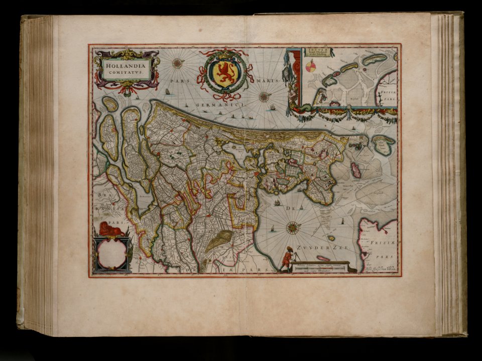
maps by willem and johannes blaeu
hendrik de leth
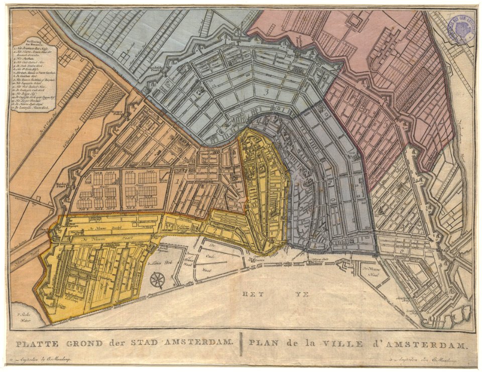
maps in the stadsarchief amsterdam
civitates orbis terrarum. urbium praecipuarum totius mundi. liber quartus
maps of hamburg by braun & hogenberg
civitates orbis terrarum. urbium praecipuarum totius mundi. liber quartus
1590s maps of denmark
18th-century maps of the aegean sea
jean-fréderic phélypeaux
civitates orbis terrarum. urbium praecipuarum totius mundi. liber quartus
maps of brixen by braun & hogenberg
maps of lyon by braun & hogenberg
1620 works in rhône
the letter writer (netscher)
17th-century genre paintings
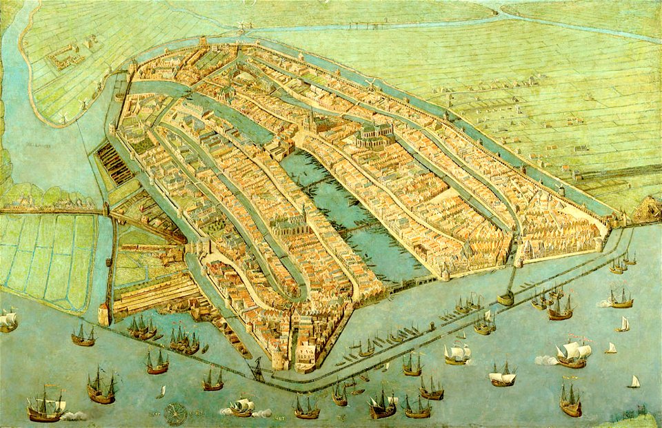
anthonisz., cornelis - gezicht op amsterdam in vogelvlucht - amsterdam museum
oil on panel
anthonisz., cornelis - gezicht op amsterdam in vogelvlucht - amsterdam museum
oil on panel
maps made in the 17th century
old maps of flanders
bird's eye view maps of new york (state)
town maps by l. r. burleigh
truscott map of st-petersburg 1753
copper
foret de soignes - zonienwoud
jacob van werden
grote kerk in haarlem in art
1689 map of haarlem
prints by cornelis anthonisz. in the rijksmuseum amsterdam
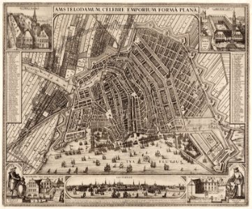
map of amsterdam, 1544
eran laor cartographic collection
hermanus johannes van den hout
charles william meredith van de velde
eran laor cartographic collection
nypl the miriam and ira d. wallach division of art, prints and photographs: print collection
samuel putnam avery collection
voyages and travels to india, ceylon, the red sea, abyssinia, and egypt, vol. 3
henry cooper (engraver)
het zegepralent kennemerlant
hendrik de leth
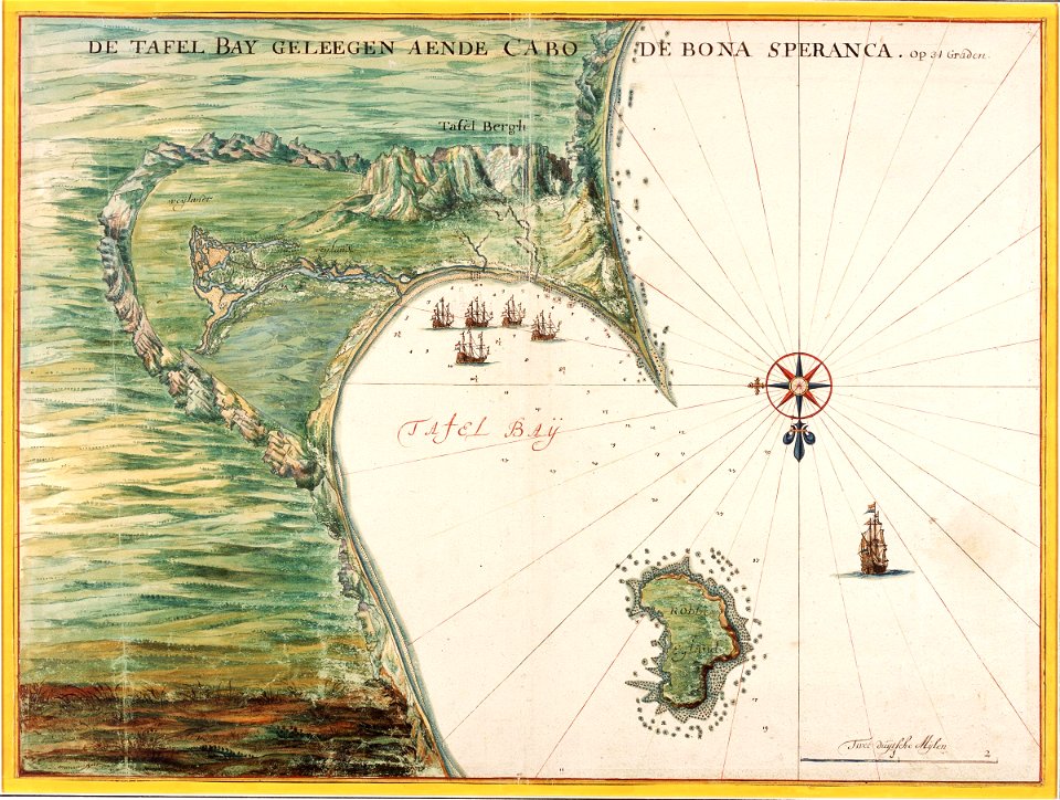
maps of the dutch east india company - south africa
1665
philippe de la rué
maps of mysia
old maps of amsterdam
evert maaskamp
maps in the stadsarchief amsterdam
claes jansz. visscher (ii)
maps in the stadsarchief amsterdam
hendrik de leth
maps in the stadsarchief amsterdam
hendrik de leth
maps in the stadsarchief amsterdam
hendrik de leth
atlas maior, vol 3 (germany) - joan blaeu, 1667 - bl 114.h(star).3
copper engraving print
atlas maior, vol 4 (netherlands) - joan blaeu, 1667 - bl 114.h(star).4
copper engraving print
atlas maior, vol 3 (germany) - joan blaeu, 1667 - bl 114.h(star).3
copper engraving print
atlas maior, vol 3 (germany) - joan blaeu, 1667 - bl 114.h(star).3
copper engraving print
atlas maior, vol 1 (northern europe, norway, and denmark) - joan blaeu, 1667 - bl 114.h(star).1
copper engraving print
atlas maior, vol 3 (germany) - joan blaeu, 1667 - bl 114.h(star).3
copper engraving print
atlas maior, vol 3 (germany) - joan blaeu, 1667 - bl 114.h(star).3
copper engraving print
atlas maior, vol 1 (northern europe, norway, and denmark) - joan blaeu, 1667 - bl 114.h(star).1
copper engraving print
atlas maior, vol 4 (netherlands) - joan blaeu, 1667 - bl 114.h(star).4
copper engraving print
atlas maior, vol 1 (northern europe, norway, and denmark) - joan blaeu, 1667 - bl 114.h(star).1
copper engraving print
atlas maior, vol 3 (germany) - joan blaeu, 1667 - bl 114.h(star).3
copper engraving print
atlas maior, vol 3 (germany) - joan blaeu, 1667 - bl 114.h(star).3
copper engraving print
atlas maior, vol 3 (germany) - joan blaeu, 1667 - bl 114.h(star).3
copper engraving print
atlas maior, vol 3 (germany) - joan blaeu, 1667 - bl 114.h(star).3
copper engraving print
atlas maior, vol 2 (sweden, russia, poland, eastern europe, and greece) - joan blaeu, 1667 - bl 114.h(star).2
copper engraving print
atlas maior, vol 1 (northern europe, norway, and denmark) - joan blaeu, 1667 - bl 114.h(star).1
copper engraving print
atlas maior, vol 3 (germany) - joan blaeu, 1667 - bl 114.h(star).3
copper engraving print
atlas maior, vol 2 (sweden, russia, poland, eastern europe, and greece) - joan blaeu, 1667 - bl 114.h(star).2
copper engraving print
atlas maior, vol 3 (germany) - joan blaeu, 1667 - bl 114.h(star).3
copper engraving print
atlas maior, vol 3 (germany) - joan blaeu, 1667 - bl 114.h(star).3
copper engraving print
atlas maior, vol 3 (germany) - joan blaeu, 1667 - bl 114.h(star).3
copper engraving print
atlas maior, vol 2 (sweden, russia, poland, eastern europe, and greece) - joan blaeu, 1667 - bl 114.h(star).2
copper engraving print
atlas maior, vol 3 (germany) - joan blaeu, 1667 - bl 114.h(star).3
copper engraving print
atlas maior, vol 2 (sweden, russia, poland, eastern europe, and greece) - joan blaeu, 1667 - bl 114.h(star).2
copper engraving print
atlas maior, vol 2 (sweden, russia, poland, eastern europe, and greece) - joan blaeu, 1667 - bl 114.h(star).2
copper engraving print
james reynolds (publisher)
john emslie
pierre jacques goetghebuer
old maps of ghent
james reynolds (publisher)
john emslie
dutch 17th-century prints in the rijksmuseum amsterdam
old maps of roermond
dutch 17th-century prints in the rijksmuseum amsterdam
old maps of roermond
plans of the lateran baptistry
templa diversa
maps of antwerp by braun & hogenberg
bibliothèque nationale de france
maps of the islands of greece by marco boschini (1658)
old maps of sifnos
maps of provence by pierre-jean de bompar
maps by hendrik hondius the younger
maps of ancona by braun & hogenberg
bibliothèque nationale de france
maps of the islands of greece by marco boschini (1658)
old maps of skyros
maps of moers by johannes mercator
bibliothèque nationale de france
maps of avignon by braun & hogenberg
bibliothèque nationale de france
old maps of middelburg, zeeland
maps by nicolaes visscher i
maps of enkhuizen by braun & hogenberg
bibliothèque nationale de france
maps by willem and johannes blaeu
17th-century maps of lorraine
maps by matthäus merian
baroque
maps by matthäus merian
baroque
maps by willem and johannes blaeu
17th-century maps of bourgogne
maps of aachen by braun & hogenberg
bibliothèque nationale de france
territorium argentoratense (1652 map)
bibliothèque nationale de france
maps of the islands of greece by marco boschini (1658)
old maps of chios
maps by jodocus hondius ii
17th-century maps of asia
maps of bruges by braun & hogenberg
bibliothèque nationale de france
maps of the islands of greece by marco boschini (1658)
old maps of lemnos
maps by pieter van der keere
old maps of bohemia
maps of algiers by braun & hogenberg
bibliothèque nationale de france
maps of ancona by braun & hogenberg
bibliothèque nationale de france
maps of dordrecht by braun & hogenberg
bibliothèque nationale de france
maps of mons (hainaut) by braun & hogenberg
maps of arras by braun & hogenberg
maps of haderslev by braun & hogenberg
maps of husum by braun & hogenberg
maps by willem and johannes blaeu
17th-century maps of dombes
maps of châteaudun by braun & hogenberg
maps of chartres by braun & hogenberg
maps of ghent by braun & hogenberg
bibliothèque nationale de france
old maps of groningen (city)
baroque
maps of werden by braun & hogenberg
maps of essen by braun & hogenberg
17th-century maps of moscow
baroque
maps by willem and johannes blaeu
old maps of malta
book pages from france
découvertes gallimard
maps of asia minor by mercator-hondius
eran laor cartographic collection
maps by pieter mortier
maps from gallica
maps by jodocus hondius
1590s maps of the world
high renaissance,renaissance
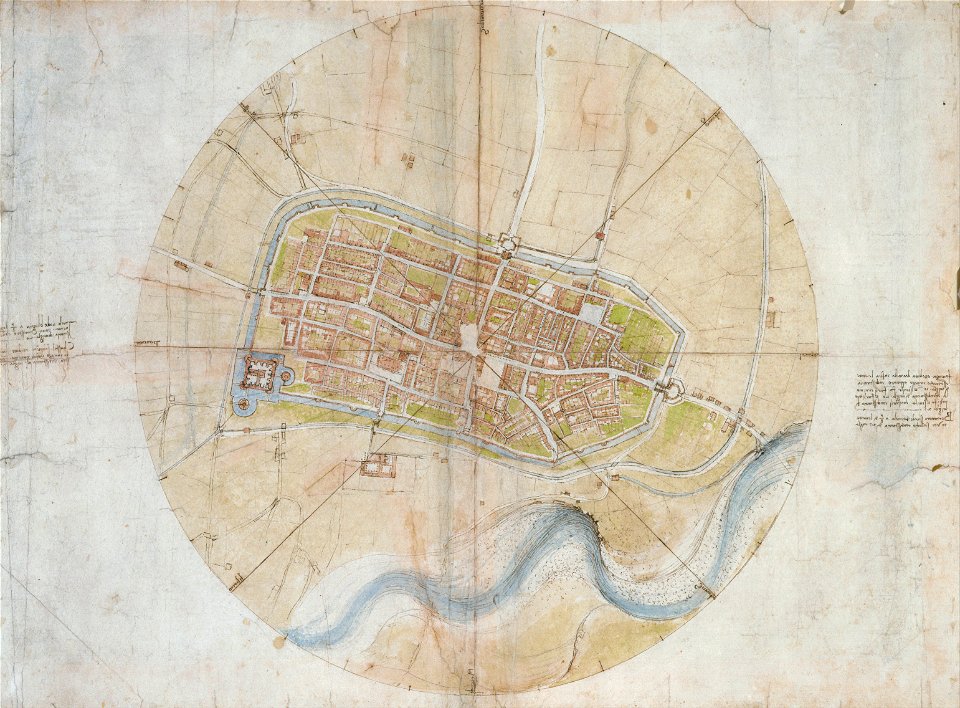
a map of imola (rcin 912284)
maps by willem and johannes blaeu
maps made in the 17th century
media contributed by erfgoed leiden en omstreken
joan blaeu
5201 - 5300 of 9,296
Next page
/ 93